Falcon 4 Campaign Links
Falcon 4.0 Forum, Falcon 4 Home, Falcon 4 Campaign, Falcon 4 Cockpits, Falcon 4 Database, Falcon 4 File Formats, Falcon 4 SRTM Terrain, Falcon 4 Terrain, Falcon 4 Textures, Falcon 4 Tools
Falcon 4 Campaign Links refers to ground unit movement links.
Objectives (ground targets like cities, factories etc) are linked together so ground units can move. These links contain all sorts of information from movement “costs” of foot soldiers, armored units all the way to air units (yeah weird). If objective does not have a link, it cannot be occupied by ground forces, unless you manually add them there with tacedit. To make any campaign work it needs to have minimum of one link between the opposing sides, this (well all links basically) need to be to the nearest objective making it short as possible. TacEdit reads the <theater>.THR file to calculate links, user must draw the links for it to calculate.
To draw a link in TacEdit v2.46 first select ALT-R to load <theater>.THR file, this brings up the relief map of the terrain. Now look at your objectives and select two of them which has road connecting them together. Select ALT-E and Edit → Flag Links option to start drawing mode, then just hold down the left mouse button and draw/drag a link between the two objectives using the road as much as possible. The link now turns purple and you get the “X links” in the bottom of tacedit screen, this means you have X number of links to calculate in the background. When the link has been calculated it turns black and tacedit moves to another possible link to calculate.  To link the roads must be used but its not 100% perfect job, don't panic if you cannot make the straight link to follow road precisely. Also some troubling spots are the intersections where there are no objectives, how to make a link where it basically would need to do 90degree turn?? Well there you can place additional objective, for example if the situation allows SAM site, depot or anything similar. If none of those options aren't available you can place Junction objective for the intersection so you can draw links nicely around that point.
Junction objectives can be placed where you need them, but try to avoid them to keep the number of objectives on your theater as low as possible, (should increase performance although we don't have any testing facts). For example in our picture here there are sort of that kind of intersection right below the blue linked objective, if you look the objective east from it there is village in middle of the road. That village cannot really nicely drawn to the west blue objectives because you'd have to make a choice whether to draw it to the norther (already linked) or the southern objective. Actually the southern is even one more road away from direct linking. So just place Junction objective to the intersection, draw links from the blue linked objective, village from east and the factory in south-west to it. Then you can link the village that was not really within direct linking to the factory. So now all objectives have links and ground units can move to all of them. Yes this is sort of difficult to explain, you can ask more help in the PMC Tactical Forum.
Coasts are also tricky, some roads can get easily broken and objectives can be in the water. Here you can see screenshot of the situation where we have broken road in the coast:

In this situation you must use TerrainView to open the L2 file and fix the auto tiling of that road, basically connecting the road so there is no gap. If you find objective in the water so its like few pixels off shore, just move it back to the land/road and link it, it will be fine like that.
Next example shows airstrip well into the ocean, here is the image:  You must move that airstrip into the east for the road, since airstrips are only placed on roads. Also other objectives if they are on roads, ground units can move and occupy them easily.
You can just manually use mouse drag to move that objective and be done with it, but you might also check the accurate coordinates of the road from TerrainView. So open up the L2 with TerrainView and the correct segment.
Now that you have the segment open, you must locate the road piece where you want the airstrip objective to be placed. Double click on that road tile and you get the X and Y coordinates from there.
This is the view of the segment where you must check out the coordinates of that road you are searching for.

As you can see we have road here like it was on the TacEdit view earlier. But now we can check out the absolute X and Y coordinates for the wanted tile where we place the airstrip, the arrow is pointing to the place I selected.
Now that you have the coordinates, simply type them into the TacEdit objective dumb and click OK, the airstrip now moves into the correct coordinates and you are free to link it normally.
In new theaters the most noticeable bug is those 3d objectives in water, so we must do all we can to move them a shore. Also we suggest you keep the important objectives at least all on road tiles (or very close), this way the ground units can easily reach the objectives.
Remember that you can always take a look at Korean save0.cam to check the links in there. If you follow the style in Korean theater, most likely you don't have no problems to make your ground buggers to move in your own theater.
Broken Links
If your links are broken, ground units cannot move. This is very very important to remember.
The trick is: If two objects are not connected via the road network (in THR that is, not TacEdit Map view. You should use Relief map here), they should not be linked to each other. See the images below.

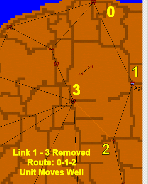
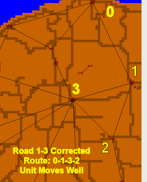
We start at 0, we want to go to 2
Falcon draws the path like 0 - 1 - 3 - 2 (Because of the links between objects + calculated cost by tile type + slopes).
Since, the road network (THR) is broken between objectives 1 and 3, when an unit reaches 1 and needs to move to 3, it can't.
There are two options to solve the problem…
- If, you remove the link between 1 and 3, Falcon will create the path like “0 - 1 - 2” or “0 - Bridge - 3 - 2” depends on cost. And since the road network is not broken from 1 to 2, your unit will leave 1 and move to 2 successfully.
- If you fix the road network between 1 and 3 using TerrainView, and the create the THR again, Falcon will draw the path as 0 - 1 - 3 - 2 again (because of the links), but this time, you unit will be able to leave 1 and go to 3, then 2.
Turns etc are not important. The units can cross bridges, make 120 degree turns on the roads no problem. It's all about links, cost and road network.