arma3:terrain:satellite-mask-image
ArmA 3 Satellite Mask Image
ArmA 3 Forum, ArmA 3, ArmA 3 Config, ArmA 3 Missions, ArmA 3 3D Modeling, ArmA 3 Scripting, ArmA 3 Terrain, ArmA 3 Texturing, ArmA 3 Tools
RGB indexed colored image which is imported to terrain builder for generating layers PNG satellite mask tile files. For details see ArmA (1) layered terrain surface.
Small example image of satellite mask:
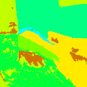
Colors represented in mask image are used with layers.cfg to designate where in your terrain different kinds of terrain types (ground detail textures and clutter) are placed.
Pennyworth's Satellite Mask Color Checker can be used for masks which suffer from too many colors in a tile.
arma3/terrain/satellite-mask-image.txt · Last modified: 2024/08/02 19:11 by snakeman