ArmA 3 Terrain Heightmap Normal Map
ArmA 3 Forum, ArmA 3, ArmA 3 Config, ArmA 3 Missions, ArmA 3 3D Modeling, ArmA 3 Scripting, ArmA 3 Terrain, ArmA 3 Texturing, ArmA 3 Tools
Terrain Heightmap Normal Map by HorribleGoat
The heightmap normal map can add shading to the the terrain, but its not what its meant to be used for since the terrain shades itself already.

Stratis normal map tile for example. These wrinkles and such don't really exist in the terrain but with this normal map they appear to be there from up and thus enhance the view. There are numerous ways to combine different data to make such a heightmap where this kind of normal map is made from but there is no magic automation to make it “fast”.

It can make things like roads pop up for example.
Little Bit of Terrain Normal Map Concept idea.
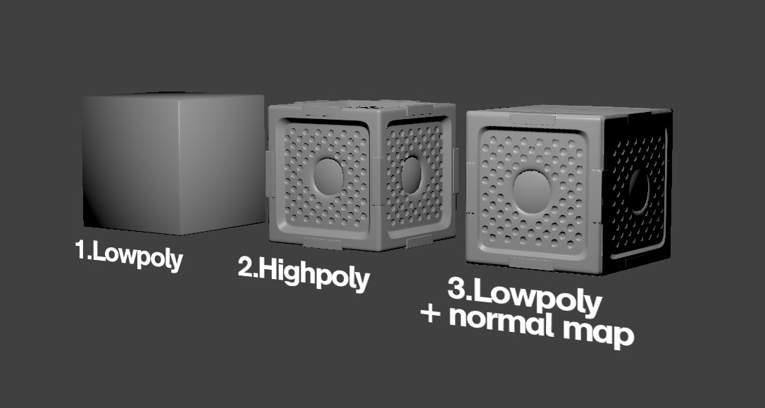
As in how normal map works and little bit of basic on how terrain normal map enhances distance details. On 3D models normal map is used to bring out details that are not on the simpler surface below it nrnx.github.io/img/1.jpg
That's what terrain normal map is for too. The terrain surface is the “flat surface of the cube on the left”, and on the right is all the detail faked on it. A normal map form heightmap does not represent the details, normal map made from heightmap represents the terrain projected on a flat surface and what the terrain normal map is for is to fake smaller details on the surface.
OK so lets make an example real quick.

This is a heightmap model

Heightmap is made out of grid and the grid can hold only so much physical detail.

Now here is some sculpted details that Id like to show at distance (this is just a very crude example).

So the terrain.

With normal map.

This being the basic idea of terrain normal map, it fakes in detail and data that the terrain itself cant hold. Now it is also not only just ground shape details like what I did here now, its also related to objects and ground types.

Now here is a drawn in ares that represent different heights. There is the base grey of normal ground level, then the lighter parts are grass fields with tall grass.

And this is the normal map shading result, now it looks extremely simple example because the heightmap I have drawn is such, but those shows that those “grassy” areas pop out“ and the road in the middle has what looks a bit like ditches at the middle.

Maybe this helps kinda.

Combined with the sculpted detail thingy.

Maybe this explains something about it or just confuses the thing even more, well to add to that this is what terrain heightmap normal map represents.

Terrains height on a flat plane.


See also ArmA 3 Terrain Tutorials