Table of Contents
ArmA 3 Terrain Builder
ArmA 3 Forum, ArmA 3, ArmA 3 Config, ArmA 3 Missions, ArmA 3 3D Modeling, ArmA 3 Scripting, ArmA 3 Terrain, ArmA 3 Texturing, ArmA 3 Tools
ArmA 3 Terrain Builder, ArmA 3 Terrain Builder Support Forum
Satellite Tiles
Terrain Builder Satellite Tiles are the small PAA files in your data\layers\ directory.
The data\layers\ PAA tiles are also called Satellite/Surface (mask) tiles, in fact PMC terminology “satellite tile” is mostly referring to splitting up a large satellite texture/mask source image into smaller tiles which are easier to edit in GIMP.
| Satellite Texture/Mask Resolution | Satellite/Surface (mask) Tiles Resolution | Tiles | File Name Range |
|---|---|---|---|
| 40960 | 1024 | 1849 | _00 to _04 |
| 71680 | 2048 | 1849 | _00 to _04 |
| 81920 | 1024 | 7396 | _00 to _08 |
| 102400 | 1024 | 16384 | _00 to _12 |
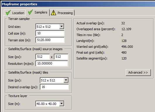
Satellite/Surface (mask) tiles setting can be found from Terrain Builder Mapframe Properties → Samplers tab.
Image from PMC ArmA 3 Ultimate Terrain Tutorial.
WRP file can have only 32,768 RVMAT indexes, otherwise it fails. What does this mean? If you have a large satellite texture/mask with additional high amount of detail, ie many colors in the mask, that generates large number of RVMAT files to layers\ dir and in the WRP file than smaller and fever color satellite mask image. Easiest way to avoid 32,768 RVMAT indexes limit is to use large satellite/surface mask tile size and if that doesn't help, then you have to reduce the splatter of individual satellite mask RGB colors.
Large Terrain Surface (mask) Tile Size
When you edit large terrains with huge satellite texture/mask images, well beyond 40,960 x 40,960 pixel resolution, its recommended to use Satellite/Surface (mask) tiles size of 2048 because otherwise you get ArmA 3 in-game mapview zooming out bug where satellite texture appears as … err difficult to explain without example screenshots but it looks like “checker board” all messed up. PMCTODO add example screenshot here.
Most large ArmA 3 PMC Terrains previously used even as small as 512 x 512 pixel resolution surface mask tile sizes, it was only when this was increased to 2048 x 2048 pixel resolution when that ugly mapview zoomed out bug went away.
I cant remember terrain specifications for the 1024 vs 2048 surface mask size difference, if your terrain is 40km x 40km with 40,960 res satellite texture/mask I recall then 1024 is large enough surface mask, but I need to verify that from my terrain builder project files or dev diaries, hey don't blame me I haven't edited terrains in over a year now! hehe. 2024-08-04T11:55:00Z PMCTODO 
